A 1972 series of Hornsey Journal articles by Ian Murray, first Chairman of Hornsey Historical Society and Haringey Council Archivist.
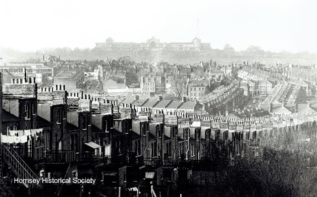
Part of the southern boundary of Hornsey is neatly marked by the ridge of high ground, known as the Hog’s Back which stretches by way of Hornsey Lane and Mountview Road to Harringay West Station.

South of this ridge lies Stroud Green and Finsbury Park which have always been within Hornsey parish. Until the end of the 19th century Hornsey extended even further south, as far as Mountgrove Road, leading into Green Lanes opposite Clissold Park.
This outlying part of Hornsey, known as South Hornsey, was returned to Stoke Newington under the Local Government Act of 1899 and its origin is to be found in the manorial structure of Hornsey at the time of the Domesday Book. At some time after the Conquest, the manor of Hornsey was divided, the part south of the Hog’s Back being acquired by one of the Canons of St Paul’s Cathedral.
According to Domesday Book there was a dispute with the Bishop over land within the Lordship of Stepney which before the Conquest had belonged to Sired, the Prebendary of Stoke Newington, and later Dean of St Paul’s. This land was apparently wrongfully appropriated by two men, Robert Fafiton and Hugh de Berners, a tenant-in-chief of the King, and in the rearrangement following the restoration of the land, a piece was taken from Stoke Newington and added to Hornsey.
Slowsh’mstall
This anomaly was not adjusted for 800 years. The name of Brownswood, which was given to this part of Hornsey, is probably derived from Robert Brun, a steward to the bishop, who held the Prebendary in 1142. Within the old Manor of Brownswood there are two places of interest to the historian, Stroud Green and Finsbury Park. Stroud Green lies just within the modern borough boundary but there is some evidence to suggest that a good part of it bordering Stroud Green Road lay formerly within the Parish of Islington.
‘Stroud’ means marshy ground covered with bushes and the ‘Green’ refers to a common or waste piece of ground. In 1500, part of this area was known as Slowsh’mstall, a name evocative of damp and unpleasantness, meaning a marshy homestead. It was probably part of the waste of the Manor of Tolenstone in Islington which is mentioned in the Domesday Book and is commemorated by Tollington Park.
Incorporated
Tolenstone was later incorporated in the Manor of Highbury and by 1373 we have references to fields at ‘Strode iuxta (next to) ‘Heyburi’. By the mid-15th century it is clear from the Highbury Court Rolls that ‘Stroud’ was considered to be part of Highbury, though by the 19th century the area now known as Stroud Green was definitely within Hornsey. By the time of the Hornsey Enclosure Act 1813 three acres of common land belonging to Hornsey existed at Stroud Green so the change in the boundary must have occurred at some time in the previous century.
Stapleton Hall takes its name from Sir Thomas Stapleton and according to Nelson’s History of Islington (1811) the building bore the date 1609 with the initials of Sir Thomas and his wife**. Old Stapleton Hall was pulled down c.1870 when the district began to be developed though the present public house and Stapleton Hall Road carries on the name.

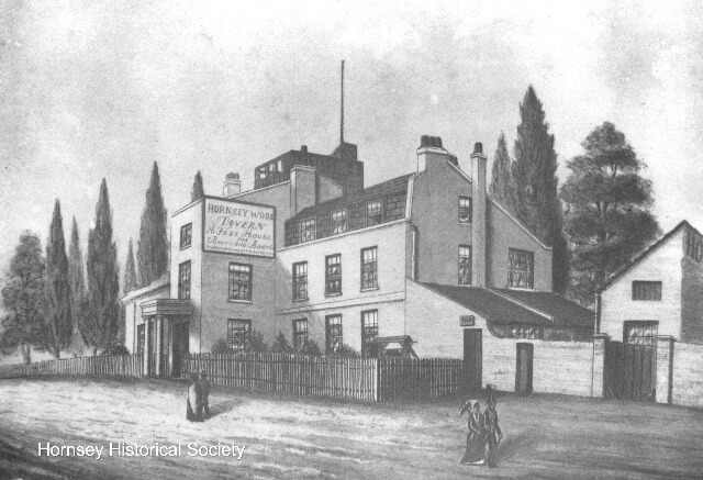
Finsbury Park occupies the site of what was Hornsey Wood, formerly known as Brownswood from which the Manor itself acquired its name. In 1575 it covered 70 acres. The wood and surrounding fields were, up to the mid-19th century, well known as a centre for recreation for Londoners and two public houses in the vicinity were particularly famous in connection with this. One was Hornsey Wood Tavern standing at the entrance to the woods, originally a private residence. It is first referred to as Hoppedehalle in 1313 when it was the residence of Richard de Kent the steward of the Manor of Hornsey and later became known as Copthall, which is the name given to it in Roques’ map of 1745.

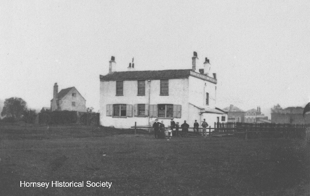
The Sluice House Tavern on the New River was the other public house, or more correctly, Eel Pie House which stood just behind the sluice house and with which it was sometimes confused, the sluice house itself housing the New River Company’s installations for controlling the flow of the New River. The tavern stood in what is now the middle of Wilberforce Road N4, the New River having been diverted and the old course filled in.
The HHS gratefully acknowledges the kind permission of Archant/Ham and High for this reproduction.
Website editor’s note
Since Ian Murray wrote this article John Nelson’s claim that Stapleton Hall took its name from Sir Thomas Stapleton and his wife has been found to be spurious. Research by John Hinshelwood, together with a section of carved panel saved in the 1980s from the house at the time of its conversion into flats, now in Bruce Castle Museum, shows that the initials are those of Thomas Draper and his wife Sarah who were alive in 1609, the date on the carved panel.
Image credits
From the Hog’s Back a view of Alexandra Palace 1972 – HHS; Hornsey Wood Tavern 1863 – HHS, The Sluice House Tavern 1859 NMPS Collection held by HHS